
Map of Yakumo with an Ainu Focus
Select a number to view the details on a separate page.

Installed Signboards
- Yakumo’s Townscape and the Pacific Ocean
- Otoshibe’s Townscape and the Pacific Ocean
- Kumaishi’s Townscape and the Sea of Japan
- Benkai Takojiro
- Sugae Masumi
- Monument to the First Step Ashore of the Pioneer Settlers
- Gravestone for the Otoshibe Village Ainu Grave-robbing Incident
- Border to the Eastern Ainu Mosir
- Monument to the Imperial Pines
- Border to the Western Ainu Mosir
- Kunne-shuma/Kuroiwa Rock
Yakumo Ainu Legends
- Cloud-Shaped Rock “Kumoishi”
- The Legend of Menash-un-mat-kenas
- The Legend of Otona River
- Expelling the Demon-Cat
- The Bear-Sending of Otoshibe
- The Kamuy-Ekasi of Mount Rukotsudake
- The Legend of Mount Obokodake
- The Monster of Yu-rap
- The Giant Bird of Mount Yurappudake
- The Tale of the Shipwreck Saved by a Fox
Yakumo at the End of the Edo Period
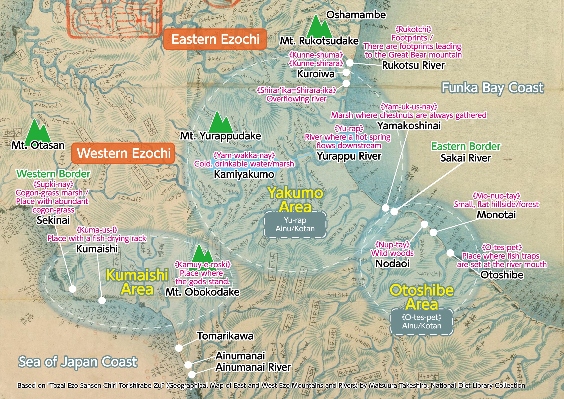
This map is an extract of “Tozai Ezo Sansen Chiri Torishirabe Zu” (Geographical Map of East and West Ezo Mountains and Rivers), created by Matsuura Takeshiro in the late Edo period, showing the portion that depicts Yakumo Town. The map shows mountains, rivers, lakes, marshes and roads, based on Matsuura Takeshiro’s observations of Ezochi, with many Ainu place-names recorded. We can see that the Sakai River, which flows along the border between Yamukushinai and Yui on the Pacific coast (Funka Bay), is marked with the kanji characters for “Border Post”, signifying the boundary between Ezochi and Wajin lands.
-
Yakumo’s Townscape and the Pacific Ocean
-
Otoshibe’s Townscape and the Pacific Ocean
-

Kumaishi’s Townscape and the Sea of Japan